لمحة تاريخية عن جورة البلوط
Jouret El Ballout, meaning “Valley of Oak Trees,” reflects both its geography: a natural low point surrounded by mountains, and the distinctive oak trees that have long adorned the area.
جورة البلوط، تعكس جغرافيتها الطبيعية: منخفض طبيعي محاط بالجبال، وأشجار البلوط المميّزة التي زيّنت المنطقة منذ زمن طويل
Jouret El Ballout (Arabic: جورة البلوط, romanized: jūrat al-balūṭ) is a village in the Matn District of Mount Lebanon Governorate, located about 20 km east of Beirut. At an altitude of around 700 meters, it offers sweeping views of the capital city and the Mediterranean Sea. The village covers 1,690,000 square meters and is bordered by the villages of Nabay, Mar Chaaya, Broummana, and Kannabit Broummana.
Though relatively modern as a residential community, the village’s land bears traces of ancient civilizations. Archaeological discoveries in the Aaranta region uncovered stone and earthen sarcophagi, remains of a fortress, Phoenician and Roman tombs, and even evidence of wood blast furnaces dating back to the Phoenician era, a testament to the area’s historical and cultural richness.
Over time, Jouret El Ballout has grown into a peaceful and vibrant village known for its fresh air, scenic views over Beirut and the Mediterranean, and its welcoming community spirit. Today it balances its heritage and natural beauty with modern amenities, offering residents and visitors alike a unique blend of history, nature, and quality of life.
جورة البلوط هي قرية تقع في قضاء المتن ضمن محافظة جبل لبنان، على بُعد حوالي 20 كيلومترًا شرق بيروت. ترتفع عن سطح البحر نحو 700 متر، وتُطل بإطلالات بانورامية على العاصمة والبحر الأبيض المتوسط. تمتد القرية على مساحة 1,690,000 متر مربع، وتحدها قرى نابيه، مار شعيا، برمانا، وقنابة برمانا
وعلى الرغم من كونها حديثة نسبيًا كمنطقة سكنية، إلا أن أرض القرية تحمل آثار حضارات قديمة. فقد كشفت الاكتشافات الأثرية في منطقة عرنتا عن توابيت حجرية وطينية، وبقايا حصن، وقبور فينيقية ورومانية، وحتى أدلة على أفران خشبية تعود إلى الحقبة الفينيقية، في دليل على غنى المنطقة التاريخي والثقافي
ومع مرور الوقت، نمت جورة البلوط لتصبح قرية هادئة ونابضة بالحياة، معروفة بهوائها النقي، ومناظرها الخلابة نحو بيروت والبحر، وروح مجتمعها المرحِّب. واليوم، تجمع القرية بين تراثها وجمالها الطبيعي من جهة، والراحة والخدمات العصرية من جهة أخرى، لتقدِّم لسكانها وزوّارها مزيجًا فريدًا من التاريخ والطبيعة وجودة الحياة
It stretches to the north of Brummana, where its spacious slopes bend in waves towards the north and west, forming hills and valleys etched with the features of its beauty. Two ridges nearly enclose its valleys, embracing them, their solid rocks interlaced with oak and valonia oak trees, clothing them with a loose robe of freshness and vitality. They open up to another peak overlooking the valley, crowned with symbols of architecture and spiritual grandeur: the See of the Diocese of Cyprus and the school of Kornet Shehwan, which has surpassed a generation in its legacy of spiritual and literary giving.
Its inhabitants loved to preserve the name “Jouret El Ballout” instead of the other name by which it was also known, “Jouret Brummana”, for in its oaks and valonia trees lies a symbol of the steadfastness and vitality of its people, who turned its valleys into fertile terraces that elevated its agricultural and industrial standing. They established there five silk factories employing about one thousand workers, making it one of the most important silk markets in Lebanon.
One of its sons, Naaman Abdo Maroun Abou Jaoude, the owner of a silk factory, won first prize at the Lyon Exhibition held in the early years of the last century.
These sources of wealth and prosperity attracted many, forming a large community. With this momentum, the town produced men of religion, medicine, engineering, science, education, and industry. Prosperity still flourishes in the rising generations, heralding a bright future.
Yet, its present community was not the first to settle this land. A people before them left traces of their presence: a massive gate in the area of Aranti “Al-Qasi”, pointing to the rocky nature of the land, as well as Phoenician and Roman tombs in the “Qalaa” area, and iron mines with remnants of their furnaces.
But it was the present community that revived life and construction, building elegant houses, planting gardens, and in 1988, rebuilding its old church, over a generation after its first construction. This church is considered one of the most beautiful in the surrounding area.
When prosperity began to decline, the people started migrating to the coast and even abroad, with large numbers leaving as early as 1881 to the United States, Brazil, Argentina, and Cuba. Yet the emigrants later returned to contribute to the flourishing of their homeland: they helped restore the church, built houses to support its income, erected distinguished residences to adorn their village, and supported public projects. Thanks to these efforts, roads were opened towards the coast and the mountains, the village was lit by electricity in 1947, supplied with water from Nahr El-Mnebooh and later from Nahr El-Kalb in 1950, and connected by automatic telephone lines from the Brummana exchange.
In 1946, a school for national education was established, succeeding the parish school that had served its mission since 1888
تمتد في الجهة الشمالية من برمانا، حيث تنحني منحدراتها الفسيحة متماوجة في اتجاهها نحو الشمال والغرب، فتؤلف الهضاب والوهاد التي تخطّ أسارير جمالها. وتكاد تطبق على وديانها رابيتان تحتضنانها، تتساند فيهما الصخور الصماء وتتعايق عليهما أشجار السنديان والبلوط، فتكسوهما ثوبًا فضفاضًا من نضارة الحياة وبسماتها. وتنفرجان عن قمة أخرى تطلّ عليها من وراء الوادي، فيظهر عليها إكليل من آيات البناء وعظمة الرسالة، هو كرسي أبرشية قبرص ومدرسة قرنة شهوان التي تجاوزت في عمرها جيلاً من العطاء الروحي والأدبي
لقد أحبّ أهلها أن يحتفظوا باسم «جورة البلوط» بدلًا من الاسم الذي عُرفت به أيضًا «جورة برمانا»، لأن في بلوطها وسنديانها رمزًا لثبات وحيوية أهاليها الذين حوّلوا وديانها إلى مدارج خصبة رفعت مكانتها الزراعية والصناعية. فقد أنشأوا فيها خمسة معامل لكرّ الحرير، كانت تستوعب ألف عامل، وبهذا اعتُبرت بين أهم أسواق الحرير في لبنان
وقد نال أحد أبنائها من أصحاب معامل الحرير، نعمان عبدو مارون أبو جودة، الجائزة الأولى من معرض ليون الذي أُقيم في أوائل القرن الماضي
وهذه المنابع للثروة واليسر جذبت إليها الكثيرين، فألّفوا فيها مجتمعًا كبيرًا. وبانطلاق الجهد أعطت من مواطنيها رجال الدين والطب والهندسة والعلم والتربية والصناعة… ولا يزال الازدهار يتفتح في الناشئة الطالعة مبشّرًا بمستقبل باهر
ولم يكن مجتمعها الحاضر أول من استوطن هذه البقعة، فقد سبقه إليها شعب ترك فيها آثار جهوده: بوابة ضخمة في محلة «عرنتي القاسي»، وهي تشير إلى طبيعة الأرض الصخرية فيها، وقبورًا فينيقية ورومانية في محلة «القلعة»، ومناجم للحديد مع بقايا أفرانها
إلا أنّ المجتمع الحاضر بعث فيها الحياة والعمران، فشيّد الدور الفخمة، وغرس الجنائن، وجدّد عام ١٩٨٨ بناء كنيستها القديمة التي كان قد انقضى جيل على بنائها الأول، وتُعد من أجمل الكنائس المجاورة
وما إن بدأ هذا الازدهار دور الانحطاط، حتى شرع الأهالي ينزحون منها إلى الساحل، وحتى إلى بلاد المهجر، حيث رحل شطر كبير منهم ابتداءً من عام ١٨٨١ إلى الولايات المتحدة والبرازيل والأرجنتين وكوبا. ثم عاد المهاجرون بدورهم للعمل على ازدهار وطنهم الأول، فساهموا في تحسين الكنيسة وبناء بيوت لها لتعزيز ريعها، وشادوا الدور الفخمة لتزيين وطنهم، وساعدوا في تحقيق المشاريع العامة. فنُفذت منها الطريق نحو الساحل والجبل، وأُنيرت بالكهرباء منذ ١٩٤٧، وجُرّت إليها مياه المنبوخ ثم مياه نهر الكلب عام ١٩٥٠، وتعمّم فيها الهاتف الآلي من مركز برمانا
وأُنشئت فيها مدرسة للتربية الوطنية منذ ١٩٤٦، فخلَفت مدرسة الرعية التي ظلّت تؤدي رسالتها منذ ١٨٨٨
Archaeological findings reveal evidence of human activity in the area dating back to the Phoenician era, including ancient wood blast furnaces. The discovery of Phoenician and Roman tombs suggests the land was settled or used in antiquity, while remains of an old fortress and stone or earthen sarcophagi uncovered in the Aaranta area further attest to its rich historical significance.
تكشف الاكتشافات الأثرية عن أدلّة على وجود نشاط بشري في المنطقة يعود إلى العصر الفينيقي، بما في ذلك أفران بدائية تعمل على الحطب لصهر المعادن. وتشير القبور الفينيقية والرومانية إلى أن هذه الأرض كانت مأهولة أو مستخدمة في العصور القديمة، كما تؤكد بقايا حصن قديم وتوابيت حجرية وطينية عُثر عليها في منطقة عرنتا على غنى الموقع وأهميته التاريخية
Over time, the area evolved into a small agricultural and residential community, making use of its fertile land, oak and pine forests, and strategic location near Beirut. Its name, Jouret El Ballout: meaning “Pit of Oak Trees”, captures both its distinctive geography and the iconic trees that define its landscape.
مع مرور الوقت، تطورت المنطقة إلى مجتمع صغير زراعي وسكني، مستفيدًا من أرضها الخصبة، وغابات البلوط والصنوبر، وموقعها الاستراتيجي بالقرب من بيروت. ويعكس اسمها "جورة البلوط"، الذي يعني "حفرة أشجار البلوط"، جغرافيتها المميّزة والأشجار الرمزية التي تُعرّف طبيعتها
1946
In 1946, the village founded its public school, marking the growth of a more organized community, before its closure in the 1980s due to shifts in population and educational needs.
1946
في عام 1946، أُسّست المدرسة الرسمية في القرية، ما شكّل خطوة نحو نمو مجتمع أكثر تنظيمًا، قبل أن تُقفل في الثمانينيات نتيجة تغيّرات في عدد السكان والحاجات التعليمية
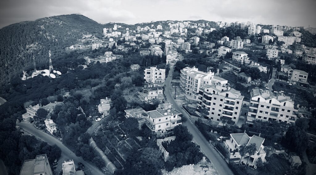
Over the years, Jouret El Ballout has developed into a quiet, green residential area with modern amenities, while maintaining its charm and natural beauty. The establishment of two private schools, Collège Louise Wegmann and Valley International School, reflects the village’s commitment to education and community life. Today, it is recognized as a sought-after destination that combines scenic landscapes, historical depth, and convenient proximity to Beirut.
على مرّ السنين، تطوّرت جورة البلوط لتصبح منطقة سكنية هادئة وخضراء، تتمتع بالخدمات الحديثة، مع الحفاظ على سحرها الطبيعي وجمالها. ويعكس تأسيس مدرستين خاصتين، Collège Louise Wegmann وValley International School، التزام القرية بالتعليم والحياة المجتمعية. واليوم، تُعتبر جورة البلوط وجهةً مميّزة تجمع بين المناظر الطبيعية الخلابة، والعمق التاريخي، والقرب المريح من بيروت
Municipality of Jouret El Ballout
Matn District, Mount Lebanon, Lebanon
بلدية جورة البلوط
جورة البلوط، قضاء المتن، جبل لبنان، لبنان
Monday to Friday from 8am till 2pm.
من الساعة 8:00 صباحًا حتى 2:00 بعد الظهر